

“Men fear time,” the old saying used to go, “but time fears the Sphinx.” That famous statue and Egypt’s Great Pyramid before which it has reclined for thousands of years have been long regarded as the most ancient monumental structures on Earth. Indeed, their late 20th century reappraisals indicated that they were even older than suspected.
Beginning in 1974, a medical physicist and colleague of Albert Einstein, Kurt Mendelssohn, showed that the Great Pyramid was not the 2560 BCE tomb of some vainglorious king described by mainstream scholars.1 Instead, the “Mountain of Ra” was raised nearly six centuries earlier, at the very outset of Pharaonic Civilisation, as a massive public works project to unify the numerous, divisive tribes of the Nile Delta in the common cause of its construction.
So too, the Great Sphinx – roughly contemporaneous, according to Egyptologists, with the Great Pyramid – has been back-dated to at least 5000 BCE – two millennia before the first Egyptian dynasty – by an American geologist at Boston University. During the early 1990s, Robert M. Schoch found that erosion on the Sphinx was not caused by the effects of wind-driven sand, as consensus opinion held, but by moving water, when conditions at the Nile Valley were far more rainy, long prior to the 26th century BCE.2
As recently as 2009, these extreme chronological disclosures were radically eclipsed by radiocarbon testing of a monumental ceremonial centre in southern Turkey. Its T-shaped pillars, arranged in concentric, stone circles emblazoned with anthropomorphic, zoomorphic and geometric bas-relief images, pushed the start of civilisation back to eleven thousand years ago. But now, even Gobekli Tepe’s primacy has been overtaken by the announcement last autumn of a much larger megalithic complex, half a world away from Anatolia, two thousand or more years older.
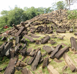
The paradigm-shattering ruins were found in western Java, fifty kilometres southwest of Cianjur, a city with more than two million residents; Jakarta lies one hundred twenty kilometres to the northwest. A half-hour drive over asphalt and unpaved roads to the village of Karyamukti passes through mountainous landscape dotted with rice paddies and farms flourishing in the volcanic soil with chillies, peanuts, pineapple and corn, then skirts an immense tea plantation. At Mount Padang, hardy visitors need about twenty minutes to climb some 370 stone steps, rising at almost a forty-degree angle, ninety-five metres to the summit, which is crowned with the largest megalithic site in southeastern Asia. It encompasses more than twenty-five hectares, including nine hundred square metres of five, rectangular, stone courtyards ascending northwest to southeast, precisely laid out on a series of landscaped terraces, and neatly organised into low walls, inner partitions, and outward gateways, all of them connected by flights of stairs.
Within and without the enclosures are dozens of standing monoliths, but many more lie scattered about. The entire complex comprises an estimated 3,703,700 black, andesite blocks ranging from one to two metres in length, and formed by geological processes into polygonal structures of five-, six- or eight-sided columns. (Andesite is an extrusive, igneous rock, a type of basalt formed by volcanic action.) Average dimensions for the columns are 0.3-by-0.3-by-1.5 metres. These smooth-sided blocks weigh from ninety to six hundred kilograms, with an average, individual weight of about three hundred kilograms. In other words, the site’s prehistoric workers transported approximately 1,111,110,000 kilograms (1,224,790 short tons) of building materials 885 metres above sea level, up the precipitous slopes of Mount Padang. Added to their burden was a non-local source for their andesite, which had to be brought in from some distant quarry unknown to academic scholars.
Archaeologists were further surprised to find traces of a kind of adhesive, glue or perhaps cement that bound some of the top courses of the walls. Beneath, investigators were perplexed by the presence of several layers of sand that had been deliberately incorporated into the original stonework by the prehistoric engineers, perhaps allowing the blocks to move and slide against each other with the motion of seismic disturbances, instead of rigidly resisting such geologic upheavals and breaking under tension. Here was possible evidence for ancient earthquake-proof construction. Java is notorious for its tectonic violence, which claimed the lives of about eighty victims as recently as 2 September 2009. But it seemed utterly inconceivable that some pre-industrial people living in a remote, Indonesian backwater could have actually applied a form of technology our modern world has only recently begun to grasp.
‘Musical’ Rocks
Contributing to the stones’ high strangeness, most of them possess an unusual quality that may have additionally warranted their distant importation by the ancient builders to the top of Mount Padang. Most of its andesite blocks and columns resonate with a bell-like tone when struck with another hard object. They belong to a rare, geological occurrence known as lithophony, the property of some rocks to emit musical sounds under percussive stress. Although only slightly more than one dozen lithophonic boulder fields have been identified in the world, most are found on private property, or have been obliterated by urban development.
Two, separate sites identically named “Ringing Rocks Park” may be visited in the United States at Upper Black Eddy and Lower Pottsgrove Township, or Stony Garden on the northern slope of Haycock Mountain, all in Pennsylvania. Yet another American “Ringing Rocks” field is found in Montana’s Deerlodge National Forest, on the southwestern flank of Dry Mountain, in Jefferson County, southeast of Butte. Australia has its own “Ringing Rocks” in northwest Queensland, and Mexico’s Cerro de las Campanas, or “Hill of the Bells,” is located on a hill in the city of Querétaro. There are the Musical Stones of Skiddaw in Cumbria, England, but Scotland’s Clach a’ Choire is more cogent to our investigation, because this “Ringing Stone Of Tiree” bears fifty-three circular “cup marks” made by New Stone Age musicians, 4,500 years ago. They, like the builders at far-off Java’s Mount Padang, discovered something unusually mystical in the bell-like sounds. Remarkably, all these various sites produce very different tones from one another; no two locations sound exactly alike.3
During laboratory testing of several lithophonic rocks in 1965, Pennsylvania geologist Richard Faas found that they created a series of tones at frequencies lower than the range of human hearing, and only became audible when they interacted with each other. Although lithophonic rocks sound metallic, their somewhat higher iron content is not responsible for such music, but rather a combination of the density of the stone and high degree of internal stress. Or so geologists speculate. In truth, beyond the cursory examinations undertaken by Faas, no actual studies to identify the source of lithophony have been made. Why some rocks produce ringing tones remains a scientific riddle.
Their anomalous appearance among the ruins of Mount Padang is another dimension of their ancient mystery. No doubt, they were used by the prehistoric inhabitants as part of their ceremonial and spiritual activities. A concentration of lithophonic rocks on the site’s first terrace is referred to as “the gamelan stones” for their suggestive arrangement and the variety of musical sounds they make. Notes they produce have been identified as F, G, D and A by Hokky Situngkir from the Bandung Fe Institute, an Indonesian research organisation.4
Alignments at Gunung Padang
Archaeo-astronomers have determined that at least several of Mount Padang’s larger standing stones point to very definite celestial phenomena, such as sunrise and sunset on the summer and winter solstices, together with those of the spring and vernal equinoxes. The ceremonial centre’s name may, in fact, have actually derived from these prehistoric solar orientations. For example, the word padang, in the language of the Sundanese people of West Java Province, translates as “bright.” Gunung Padang, the archaeological zone itself, is commonly referred to by native residents as Sundapura, or “the Shrine of the Sun,” while the hill on which the ruins are located (“Mount Padang”) is traditionally called Parahyang Padang: “Where The Sun Ancestors Dwell,” or “Place Of The Ancestors Of The Sun.” These names or titles imply that the original inhabitants were astronomer-priests and/or priestesses, who aligned some of their monoliths with important solar positions. As such, these “Sun Ancestors” were light-worshippers, not unlike the European megalith-builders, who often oriented their own standing stones in western France and the British Isles with identical solar coordinates. Today, Gunung Padang is still sought out as a holy place by the two hundred to seven hundred visitors, most of them religious pilgrims, who visit every month.
Geomantic alignments are also in evidence. Terrace I is deliberately aligned with nearby Mount Gede, where Karuhun cemetery has been revered for untold generations as the country’s oldest ancestral burial ground. Five, crudely sculpted, andesite thrones stand in Terrace II; six more are found in Terrace V. Although overshadowed by their massive courtyards, Mount Padang’s hundreds of stone terraces are themselves engineering marvels, two metres in height and diameter, with an uncanny resemblance to their far better known agricultural counterparts at another mountainous location on the other side of the world, in the Inca citadel of Machu Picchu, among the Peruvian Andes.
The Mysterious Nan Madol
But this South American parallel is not Gunung Padang’s only overseas’ comparison. No less great is an astounding, perhaps kindred mystery 4,345 kilometres northeast from Java, in a remote corner of the western Pacific Ocean. Off the coast of the Micronesian island of Pohnpei – “Built Upon An Altar” – stand the massive ruins of a long-dead archaeological site. Incongruously built on a coral reef less than two metres above sea level, Nan Madol – “Spaces In Between” – is a series of rectangular islands and colossal towers choked by draping vegetation. Ninety-two man-made islands are enclosed within the “downtown” area’s 2.6 square kilometres. All are inter-connected by an extensive network of what appear to be massive canals, each nine metres across and more than one metre deep at high tide.
An estimated two hundred fifty million tons of prismatic basalt – related to Gunung Padang’s andesite – went into the construction of Nan Madol. Its stone girders rise in a cribwork configuration to eight metres. Between four and five million stone columns went into the construction of this prehistoric megalopolis. These prismatic columns range in length from one to four metres, although many reach six metres. Their average weight is around five tons each, but the larger examples weigh twenty or twenty-five tons apiece. An estimated four to five million basalt pillars, girders and logs went into building Nan Madol. It is, in effect, a double-walled enclosure comprising thirteen thousand, five hundred cubic metres of coral, with an additional four thousand, five hundred cubic metres of basalt. Remove all concealing vegetation, and visitors would behold crudely worked masses of basalt contrasting with orderly courses of stone rising in massive towers and overpowering walls amid a complex of smaller, rectangular buildings and man-made lakes interconnected by dozens of canals and numerous steps, sometimes formed into grand staircases, and spread out over eighteen square kilometres.
Construction migrated to the main island of Pohnpei, where a rectangular enclosure fifteen metres long by eleven metres wide, with bisecting, one-metre-high interior wall, was discovered in a remote, swampy meadow high in the mountains; its configuration and mountaintop setting are particularly reminiscent of Gunung Padang. Although the Micronesian island’s twin courtyards contain a five hundred square-metre area, a pair of inner platforms are only a third of a metre high. As at Nan Madol, roughly cut basalt boulders and basalt “logs” were stacked to form the enclosure. Several others stand on Pohnpei’s southwest coast, with the largest example atop a two hundred forty-metre-high mountain. The summit is entirely surrounded by walls about two metres high connected via paved walkways to several terraced platforms.
No one knows who raised them, when or why. Micronesian myth recounts only that exceptionally tall, twin-brother sorcerers, named Olisihpa and Olsohpa, arrived sometime during the ancient past in a “large canoe” from their distant homeland. It was a great kingdom of glittering splendour, until falling stars and earthquakes eventually destroyed Kanamwayso, which sank to the bottom of the sea. This native oral tradition seems like a variation on the more famous story of Mu, or Lemuria, a deeply ancient and supposedly sophisticated, pan-Pacific civilisation that exerted lasting influence on both Asia and America prior to its destruction by a natural catastrophe similar to the tsunami that ravaged northern Japan, in 2010. Before the analogous loss of Kanamwayso, Olisihpa and Olsohpa allegedly built the basalt enclosures and staircases that continue to grace Nan Madol and Pohnpei. Despite more than one hundred years of scientific investigations, however, no known culture has been associated with these places. Meanwhile, the moist, tropical climate skewers accurate carbon-dating at both locations.
Nor is their original purpose entirely clear. Nothing about either location suggests real urban centres, lacking as they do any provision for food production or storage. No human burials have been found there, save a few, individual skeletons of above-average stature – calling to mind local myths of the founding-fathers, Olisihpa and Olsohpa – unearthed by Japanese archaeologists during the 1930s. The rectangular arrangement of walls with regularly spaced openings and partitions suggest a ceremonial function. But for what people, and why in this extremely remote, obscure corner of the vast Pacific? Nevertheless, Nan Madol’s and Pohnpei’s fundamental resemblances to Gunung Padang imply, at the very least, a relationship of some kind, however inconceivable.
14,000 BCE?
Yet more extraordinary than even these comparisons and the monumental greatness of the Indonesian site itself is its uniquely profound age. The first archaeological survey of Gunung Padang appears in a “Report, the Department of Antiquities” (Rapporten van de Oudheidkundige Dienst) for Holland’s colonial office, whose anonymous author posited during 1914 that the ruins could not predate the official beginning of Java’s history in the early 5th century CE, although they appeared much older. For the rest of the 20th century, the site went unrecognised by the outside world, even after it was briefly mentioned by the prolific Dutch archaeological author, Dr. N.J. Krom, in 1946’s Under Palm And Banyan Trees.5
Thirty-three years later, a Canberra team from the Australian National University’s Centre for Archaeological Research – “dedicated to investigating and learning with and about the people, languages, and land of Asia and the Pacific region” – returned for the site’s first, scientific examination.6 In doing so, they determined that Gunung Padang was far older than previously imagined. Lichen growth alone covering many of the megaliths bespoke an antiquity going back millennia before Java’s earliest known culture. Not until February 2012, however, was a State-sponsored evaluation of the site carried out, when thorough radiocarbon testing revealed it was built and first occupied about 4,800 years ago. This surprisingly early Third Millennium BCE date placed Gunung Padang squarely within Western Europe’s Megalithic Age, with implications for transoceanic contact, however heretical such considerations struck conventional scholars.
But as the researchers were carrying out their investigations, they noticed traces on Mount Padang’s surface of what might be other, underground structures. No less a supporter of science than the President of Indonesia himself, Susilo Bambang Yudhoyono, lavished the archaeologists with costly GSSI and Multi-Channel SuperSting R-8 ground-penetrating radar units, plus GEM-Ovenhausser geo-magnetometers. These state-of-the-art instruments readily found and accurately confirmed the existence of large and small chambers, walls, gates and staircases buried deep beneath the often-visited, open-air ruins in a virtual subterranean mirror image of Gunung Padang.
According to team leader and geologist, Dr. Danny Hilman Natawidjaja, “3-D geo-electric and geo-radar [procedures] discovered two doors in the hallway” of a chamber measuring ten-by-ten-by-ten metres at a depth of twenty-five metres.7 Throughout last summer and into early fall, he and his twenty colleagues – leading seismologists, philologists, archaeologists, anthropologists, and petrographers – carefully dredged up organic materials, which were sent for laboratory testing in the United States, because the Indonesians were determined to avoid any appearance of politically motivated results.
“US lab validates Cianjur ‘ancient structure’ theory,” The Jakarta Post announced on 5 November. “A recent analysis of carbon-dating by the Miami-based Beta Analytic Lab has apparently validated findings by a government-sanctioned team that a man-made structure lies buried under Mount Padang in Cianjur, West Java. The lab used samples of sand, soil and charcoal found at a depth of between three and twelve metres beneath the mountain’s surface. Based on geo-electric, geo-radar and geo-magnetic [surveys], a large chamber is buried at least up to fifteen metres from the surface… Carbon-dating test results from the Miami lab show that the structure could date back to 14,000 B.C., or beyond.”8
Since publication of The Jakarta Post report, repeated and additional analysis by Beta Analytic scientists confirmed their initial 14,000 BCE findings. The significance of this discovery cannot be over-stated, because it crosses the Ice Age event horizon. Even Turkey’s Gobekli Tepe, for all its Tenth Millennium BCE antiquity, came into being only after the close of the last glacial epoch, when environmental conditions were moderating sufficiently to allow for the development of proto-civilisation. Less distracted by the incessant challenges to their survival, our ancestors were afforded opportunities for broader, more complex social cooperation. But Gunung Padang proves that humans were already in possession of a relatively high culture two thousand years earlier, while the Ice Age was still in progress.
This “Shrine of the Sun” has radically pushed back the origins of civilisation to remoter levels of time and space, because mainstream palaeo-anthropologists, fixated on Europe and the Near East, are resistant to the very notion of mankind’s transition from ‘savagery’ in Indonesia. Yet, it is precisely here that Stephen Oppenheimer, a British geneticist, member of Green Templeton College, Oxford, and an honorary fellow of Liverpool School of Tropical Medicine, traced the beginnings of civilised mankind with his controversial Eden in the East, in 1999.9 It had been preceded during the previous century by The Lost Continent of Mu, written by another Englishman, James Churchward, an Imperial British Army colonel serving in India, where his translation of original Hindu monastery source materials likewise recorded how humans took that first step in the Western Pacific realm.10 My own The Lost Civilization of Lemuria (2006) and Before Atlantis (2013) similarly trace the rise of homo erectus in Java, his Pacific-wide dispersal and accelerated evolution after the eruption of history’s greatest volcanic event, and his descendants’ subsequent invention of civilisation.
These conclusions are wonderfully brought to life by recognition of Gunung Padang as Man’s earliest-known megalithic complex. Its apparent sophistication declares that it was not the first, but must have been preceded by the construction of even earlier ceremonial centres. Civilisation is, therefore, older than we presently comprehend. If, however, the quest for its ultimate origins goes on, and deeper into the past than ever imagined, then at the very least, Gunung Padang is pointing us in their proper direction.
Footnotes
1. Kurt Mendelssohn, The Riddle of the Pyramids, London: Thames & Hudson, 1974.
2. Robert M. Schoch, Voices of the Rocks, NY: Harmony, 1999.
3. Ringing Rocks Park, Upper Black Eddy, Pennsylvania, www.youtube.com/watch?v=V4VtjFhysgc; Ringing Rocks Park, Lower Pottsgrove Township, Pennsylvania, www.youtube.com/watch?v=NBfrLoBpsIQ; Ringing rocks, Queensland, Australia, www.youtube.com/watch?v=dl_zL4g2gvs; Musical Stones of Skiddaw, England, www.youtube.com/watch?v=inWKcmVEwvs; Ringing Rocks, Montana, www.youtube.com/watch?v=smiCS1Ixfts; Cerro de las Campanas, Querétaro, Mexico, www.youtube.com/watch?v=_dMRcnlZ2tk; The Ringing Stone, or Clach a’ Choire, Scotland, www.youtube.com/watch?v=eNn-4O_G-bU
4. www.abovetopsecret.com/forum/thread880575/pg1
5. Dr. N. J. Krom, Onder Palmen En Waringins, Holland: Uitgeverij in Den Toren, 1946.
6. ANU Centre for Archaeological Research, chl.anu.edu.au/archaeology/car.php
7. www.abovetopsecret.com/forum/thread880575/pg1
8. “U.S. lab validates Cianjur ‘ancient structure’ theory,” 5 November 2012, The Jakarta Post, www.thejakartapost.com/news/2012/11/05/us-lab-validates-cianjur-ancient-structure-theory.html.
9. Stephen Oppenheimer, Eden in the East, London: George Weidenfeld & Nicholson, Ltd., 1999.
10. Col. James Churchward, The Lost Continent of Mu, U.S.: Brotherhood of Life, 1987 reprinting of the 1924 original.
11. Frank Joseph, The Lost Civilization of Lemuria, U.S.: Bear and Company, 2006; Before Atlantis, U.S.: Bear and Company, 2013.
© New Dawn Magazine and the respective author.
For our reproduction notice, click here.